Loading depth chart…
 Sign inSign up free Sign inSign up free Sign inSign up free
Lake depth chart
Today's read
Rating depth structure for european perch.
Recent public catches load as you reach this section.
294.1-acre lake in Estonia. The lake tops out around 11 m. The depth chart comes from Estonian Environment Agency / Tallinn University bathymetric survey data, so the contours are survey-derived rather than computer-modeled. Below is the species-by-species picture, pulled from the same data the map uses.
Veekogu joonistub 119 hektari suurusena, kallast 9.8 km, ja vees on üks saar. Kaldajoon on tugevalt liigestatud (indeks 2.6) — lahed ja neemed igal pool, mis mitmekordistab püütava serva. Umbes 94% pinnast on madalam kui ~5 m — seal elab toiduahel. Otsast otsani mõõdab veekogu umbes 3.9 km, kõige laiemas kohas 0.6 km. Lähim kaardistatud veekogu on Ülemiste järv, 8 km kirdesse.
Tasuta interaktiivne sügavuskaart — Männiku järv, Eesti: sügavusjooned päris mõõdistusandmetest kuni 11 m (37 jalga), lisaks parimad püügikohad liikidele ahven ja haug. Sügavusjooned põhinevad päris mõõdistusandmetel (Keskkonnaagentuur / Tallinna Ülikool, CC BY 4.0). Kasuta suunisena, mitte navigeerimiseks.
Early season european perch use the shallows, holding in 1 to 3.5 m. Expect a summer slide to 2.5 to 8.5 m, then a winter hold in 3.5 to 10 m. Put Deep basin first on the milk run — a deep basin near 10 m that grades prime for fall. In summer the feeding windows fall in early morning. Tie on a drop-shot micro plastics or a small crankbait (perch pattern) and you're in the game.
| Hooaeg | Sügavus | Parim aeg | Alusta siit | Landid |
|---|---|---|---|---|
| Kevad | 1 to 3.5 m | midday & dawn | Shallow bay flat (0.5 m) | Small jig + curly tail, Inline spinner #1-2 |
| Suvi | 2.5 to 8.5 m | dawn | Deep basin (10 m) | Drop-shot micro plastics, Small crankbait (perch pattern) |
| Sügis | 3 to 10 m | midday | Deep basin (10 m) | Jigging spoon (small), Drop-shot on deep flats |
| Talv | 3.5 to 10 m | midday & dawn | Deep basin (10 m) | Tungsten jig + maggots, Small balance jig |
Come spring, look for northern pike tight to the bank in 0.5 to 2.5 m. Expect a summer slide to 2.5 to 6 m, then a winter hold in 1.5 to 4.5 m. Start at Shallow bay flat. It's a weed flat holding about 0.5 m of water and rates good come spring. Prime time lands in early morning and the evening. A bucktail or a weedless spoon over cabbage is the honest summer answer here.
| Hooaeg | Sügavus | Parim aeg | Alusta siit | Landid |
|---|---|---|---|---|
| Kevad | 0.5 to 2.5 m | midday & dawn | Shallow bay flat (0.5 m) | #5 inline spinner, Spoon (red/white) |
| Suvi | 2.5 to 6 m | dawn & dusk | open water | Bucktail, Weedless spoon over cabbage |
| Sügis | 2 to 5.5 m | midday & dawn | Shallow bay flat (0.5 m) | Big rubber (Bull Dawg style), Husky-style jerkbait |
| Talv | 1.5 to 4.5 m | midday | Shallow bay flat (0.5 m) | Tip-ups, Large jigging spoon |
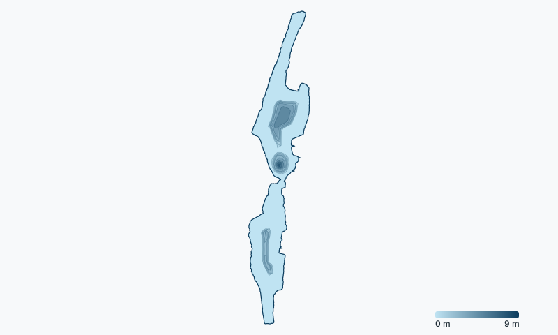
Männiku järv carries 6 mapped structure features, topping out (or rather bottoming out) at Deep basin, about 10 m down.
Season dates, license requirements, and size and bag limits for Estonia waters are set by the Keskkonnaamet (Estonian Environmental Board) — and special regulations can apply to Männiku järv specifically, so confirm the current rules before you fish.
Check the official Estonia fishing regulations →
Männiku järv is about 37 ft (11 m) deep at its deepest point. The depth chart comes from Estonian Environment Agency / Tallinn University bathymetric survey data, so the contours are survey-derived rather than computer-modeled.
Männiku järv on sügavaimas kohas umbes 11 meetrit (37 jalga). Sügavused põhinevad päris mõõdistustel.
Anglers target european perch, northern pike on Männiku järv.
Deep basin is the top-rated area: a deep basin in about 33 ft of water that rates prime for european perch in fall. The interactive chart above rates every spot for each species and season.
For european perch, the summer bite is best in early morning. Each species page section below lists the seasonal windows, and the map shows a live NOW badge when you're inside one.
Fishing on Männiku järv is regulated by the Keskkonnaamet (Estonian Environmental Board). Check the official Estonia regulations for current license requirements, season dates, and size and bag limits — special regulations can apply to this specific water.
Ülemiste järv 8 km · Maardu järv 19.3 km · Klooga järv 27.4 km · Paunküla veehoidla 45.1 km · Kahala järv 48.3 km · Tänavjärv 54.7 km · Veskijärv 57.9 km · Lohja järv 59.5 km · Kaisma järv 72.4 km · Upinniemenselkä - East 74 km, FI · Viitna Pikkjärv 74 km · Helsinki-Porkkala - North West 78.9 km, FI
See how Männiku järv stacks up: best northern pike lakes in Estonia · best european perch lakes in Estonia
Browse all Estonia fishing maps. See every water on DepthScout. Bathymetry credit: Estonian Environment Agency / Tallinn University, CC BY 4.0. How we build these maps. Fish here with a sonar unit that logs? Send us your depth data and we'll improve this chart, credited to you. For fishing guidance only, never navigation.