Loading depth chart…
 Sign inSign up free Sign inSign up free Sign inSign up free
Lake depth chart
Today's read
Rating depth structure for brown trout.
Recent public catches load as you reach this section.
1,024-acre lake in Norway. The lake tops out around 67 m. The depth chart comes from Norwegian Water Resources and Energy Directorate (NVE) bathymetric survey data, so the contours are survey-derived rather than computer-modeled. What the data behind the map says about each species, season by season:
Vannet tegner ut 414 hektar med 16.3 km strand. Strandlinjen er sterkt oppfliket (indeks 2.3) — viker og nes overalt, som mangedobler den fiskbare kanten. Omtrent 3% av flaten er grunnere enn ~5 m — der maten finnes. Fra ende til ende måler vannet omtrent 5.3 km, på det bredeste 3.5 km. Vannet ligger i Lund kommune. Nærmeste kartlagte vann er Eidsvatnet, 8 km mot sørvest.
Gratis interaktivt fiskekart — Hovsvatnet, Norge: dybdekoter fra ekte dybdemålinger ned til 67 m (220 fot), og de beste fiskeplassene for ørret, abbor, gjedde med flere. Dybdekartet er modellberegnet fra innsjøens virkelige strandlinje og største dybde — bruk det som en veiledning, aldri til navigasjon.
Start shallow in spring: brown trout sit in 1 to 7.5 m that time of year. Warm water sends them out to 7.5 to 18 m; cold water stacks them in 1.5 to 11 m. Top water on the chart: Main-lake point, a point in the 7.5 m range, prime in spring. Fish it in after dark and early morning and you'll meet the bite. Throw a spoon at the thermocline or a deep stickbait (night) until the fish tell you otherwise.
| Sesong | Dybde | Beste tid | Start ved | Agn |
|---|---|---|---|---|
| Vår | 1 to 7.5 m | dawn & dusk | Main-lake point (7.5 m) | Stickbait off planer boards (shallow), Small spoon along mud lines |
| Sommer | 7.5 to 18 m | night & dawn | Main-lake point (7.5 m) | Spoon at the thermocline, Deep stickbait (night) |
| Høst | 1.5 to 9 m | dusk & dawn | Main-lake point (7.5 m) | Jerkbait over gravel, Casting spoon |
| Vinter | 1.5 to 11 m | dawn | open water | Jigging spoon, Small stickbait (slow) |
When the water first warms, european perch slide up into 1 to 3.5 m. Summer is a 2.5 to 8.5 m game here, winter a 3.5 to 10 m one. Start at Back-bay flat. It's a feeding flat holding about 0.5 m of water and rates good come spring. The feeding windows run early morning. Keep a drop-shot micro plastics or a small crankbait (perch pattern) rigged through the warm months.
| Sesong | Dybde | Beste tid | Start ved | Agn |
|---|---|---|---|---|
| Vår | 1 to 3.5 m | midday & dawn | Back-bay flat (0.5 m) | Small jig + curly tail, Inline spinner #1-2 |
| Sommer | 2.5 to 8.5 m | dawn | Shallow bay flat (4.5 m) | Drop-shot micro plastics, Small crankbait (perch pattern) |
| Høst | 3 to 10 m | midday | open water | Jigging spoon (small), Drop-shot on deep flats |
| Vinter | 3.5 to 10 m | midday & dawn | Shallow bay flat (4.5 m) | Tungsten jig + maggots, Small balance jig |
Spring northern pike on Hovsvatnet hold shallow, usually 0.5 to 2.5 m. They move out to 2.5 to 6 m in summer and finish the year down in 1.5 to 4.5 m. Put Back-bay flat first on the milk run — a feeding flat near 0.5 m that grades prime for spring. The feeding windows run early morning and the evening. The summer box starts with a bucktail or a weedless spoon over cabbage.
| Sesong | Dybde | Beste tid | Start ved | Agn |
|---|---|---|---|---|
| Vår | 0.5 to 2.5 m | midday & dawn | Back-bay flat (0.5 m) | #5 inline spinner, Spoon (red/white) |
| Sommer | 2.5 to 6 m | dawn & dusk | Shallow bay flat (4.5 m) | Bucktail, Weedless spoon over cabbage |
| Høst | 2 to 5.5 m | midday & dawn | Shallow bay flat (4.5 m) | Big rubber (Bull Dawg style), Husky-style jerkbait |
| Vinter | 1.5 to 4.5 m | midday | Shallow bay flat (4.5 m) | Tip-ups, Large jigging spoon |
Spring puts lake whitefish in skinny water — 4.5 to 14 m is the zone. As the season builds they drop to 12 to 27 m, wintering in 7.5 to 21 m. Spring lake whitefish concentrate at Shallow bay flat, a prime-rated feeding flat around 4.5 m. Warm-month bites cluster around early morning. A blade bait vertical or a small jigging spoon covers the summer program.
| Sesong | Dybde | Beste tid | Start ved | Agn |
|---|---|---|---|---|
| Vår | 4.5 to 14 m | midday & dawn | Shallow bay flat (4.5 m) | Small jig + waxworm, Blade bait (small) |
| Sommer | 12 to 27 m | dawn | open water | Blade bait vertical, Small jigging spoon |
| Høst | 2.5 to 9 m | dusk | Main-lake point (7.5 m) | Small spoon (gold), Jig + plastic larva |
| Vinter | 7.5 to 21 m | midday & dawn | Shallow bay flat (4.5 m) | Jigging spoon + bead chain, Tungsten jig + waxie |
Spring puts arctic char in skinny water — 1 to 4.5 m is the zone. As the season builds they drop to 6 to 18 m, wintering in 3 to 12 m. Spring arctic char concentrate at Shallow bay flat, a good-rated feeding flat around 4.5 m. Warm-month bites cluster around early morning. A jigging spoon vertical or a tube jig (smelt) covers the summer program.
| Sesong | Dybde | Beste tid | Start ved | Agn |
|---|---|---|---|---|
| Vår | 1 to 4.5 m | midday & dawn | Shallow bay flat (4.5 m) | Small casting spoon (silver/orange), Jerkbait (small) |
| Sommer | 6 to 18 m | dawn | open water | Jigging spoon vertical, Tube jig (smelt) |
| Høst | 2.5 to 9 m | midday & dusk | open water | Casting spoon (orange/gold), Beadhead streamer |
| Vinter | 3 to 12 m | midday & dawn | open water | Jigging spoon (glow/silver), Tungsten jig + plastic |
Spring european eel on Hovsvatnet hold shallow, usually 1.5 to 6 m. By summer they slide out to 2 to 8.5 m, and by winter most fish are in 5.5 to 15 m. The chart's best answer is Shallow bay flat — feeding flat, 4.5 m, good for winter. Prime time lands in after dark and the evening.
| Sesong | Dybde | Beste tid | Start ved | Agn |
|---|---|---|---|---|
| Vår | 1.5 to 6 m | dusk & night | open water | |
| Sommer | 2 to 8.5 m | night & dusk | open water | |
| Høst | 3 to 12 m | night | open water | |
| Vinter | 5.5 to 15 m | midday | Shallow bay flat (4.5 m) |
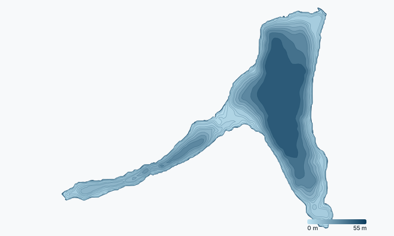
The chart marks 6 structure features on Hovsvatnet; the deepest is Deep basin at about 62 m.
Season dates, license requirements, and size and bag limits for Norway waters are set by the Norwegian Environment Agency (fishing rules) — and special regulations can apply to Hovsvatnet specifically, so confirm the current rules before you fish.
Check the official Norway fishing regulations →
Hovsvatnet is about 220 ft (67 m) deep at its deepest point. The depth chart comes from Norwegian Water Resources and Energy Directorate (NVE) bathymetric survey data, so the contours are survey-derived rather than computer-modeled.
Hovsvatnet er på det dypeste omtrent 67 meter (220 fot). Dybdene kommer fra virkelige målinger.
Anglers target brown trout, european perch, northern pike, lake whitefish, arctic char, european eel on Hovsvatnet. This isn't a survey of the water — none is published for it — but an informed estimate from the species common to the region, narrowed by this water's depth, size and each species' range.
Back-bay flat is the top-rated area: a feeding flat in about 2 ft of water that rates prime for northern pike in spring. Every other rated spot, per species and season, is on the map above.
For brown trout, the summer bite is best in after dark and early morning. Each species page section below lists the seasonal windows, and the map shows a live NOW badge when you're inside one.
Fishing on Hovsvatnet is regulated by the Norwegian Environment Agency (fishing rules). Check the official Norway regulations for current license requirements, season dates, and size and bag limits — special regulations can apply to this specific water.
Eidsvatnet 8 km · Lundevatnet 12.9 km · Sirdalsvatnet 12.9 km · Selura 24.1 km · Øygreisvatnet 24.1 km · Slettebøvatnet 27.4 km · Fotlandsvatnet 27.4 km · Svelavatnet 27.4 km · Hofreistæ 27.4 km · Eikesvatnet 29 km · Galdalsvann 30.6 km · Indra Vinjavatnet 32.2 km
See how Hovsvatnet stacks up: best northern pike lakes in Norway · best european perch lakes in Norway · best brown trout lakes in Norway · best lake whitefish lakes in Norway
Browse all Norway fishing maps. See every water on DepthScout. Depth data: Norwegian Water Resources and Energy Directorate (NVE), Lake depth data (NLOD / CC BY 4.0). How we build these maps. Fish here with a sonar unit that logs? Send us your depth data and we'll improve this chart, credited to you. For fishing guidance only, never navigation.