Loading depth chart…
 Sign inSign up free Sign inSign up free Sign inSign up free
Lake depth chart
Today's read
Rating depth structure for yellow perch.
Recent public catches load as you reach this section.
48-acre lake in Leeds and Grenville United Counties, Ontario. The lake tops out around 3 ft. The depth chart comes from Ontario Ministry of Natural Resources and Forestry bathymetric survey data, so the contours are survey-derived rather than computer-modeled. The depth data here comes from the Ontario MNRF survey of 1975, a decades-old survey (a transect sounding survey). Species by species, here's what the data says the year looks like.
Bacchus Mud Lake maps at 47 acres behind 1.2 miles of shoreline. At index 1.2 the outline is almost a bowl — read the depth changes, not the shoreline. Nothing on this chart breaks 15 ft, which makes the whole surface littoral: weeds, bait and ambush cover everywhere. Tip to tip the water measures near 0.5 mi with a 0.2-mi widest point. It sits in Leeds and Grenville United Counties. Its nearest charted neighbour, Big Rideau Lake, is 6 mi to the southwest.
These fish are listed in an exact-water agency record as forage or ecological context. They are not target-species profiles and do not affect DepthScout's Prime, Good, or Fair spot ratings.
Official Ontario MNRF Fish ON-Line record. The listing documents source-recorded presence, not present abundance or guaranteed catchability.
Spring puts yellow perch in skinny water — 1 to 3 ft is the zone. Summer fish stay in 1 to 3 ft, and winter fish hold in 1 to 3 ft. Shallow bay flat is the standout, a weed flat at roughly 1 ft, rated prime for spring yellow perch. Plan around early morning in the warm months. A drop-shot micro plastics or a small spoon tipped with worm covers the summer program.
Depth note: when a documented seasonal range extends below this chart, the table shows the deepest mapped working water, not a verified holding depth.
| Season | Depth | Best window | Start at | Go-to baits |
|---|---|---|---|---|
| Spring | 1 to 3 ft chart-limited; documented 3 to 12 ft | midday & dawn | Shallow bay flat (1 ft) | Small jig + curly tail, Perch-pattern micro crank |
| Summer | 1 to 3 ft chart-limited; documented 10 to 30 ft | dawn | Deep basin (3 ft) | Drop-shot micro plastics, Small spoon tipped with worm |
| Fall | 1 to 3 ft chart-limited; documented 12 to 35 ft | midday | Deep basin (3 ft) | Jigging spoon (small), Perch rig / spreader |
| Winter | 1 to 3 ft chart-limited; documented 15 to 35 ft | midday & dawn | Deep basin (3 ft) | Tungsten jig + spikes, Rattle spoon (small) |
Spring northern pike on Bacchus Mud Lake hold shallow, usually 1 to 3 ft. Depth-wise the year is flat: 1 to 3 ft in summer, 1 to 3 ft once it turns cold. Put Shallow bay flat first on the milk run — a weed flat near 1 ft that grades prime for spring. The feeding windows run early morning and the evening. The summer box starts with a bucktail or a weedless spoon over cabbage.
Depth note: when a documented seasonal range extends below this chart, the table shows the deepest mapped working water, not a verified holding depth.
| Season | Depth | Best window | Start at | Go-to baits |
|---|---|---|---|---|
| Spring | 1 to 3 ft chart-limited; documented 2 to 8 ft | midday & dawn | Shallow bay flat (1 ft) | #5 inline spinner, Spoon (red/white) |
| Summer | 1 to 3 ft chart-limited; documented 8 to 20 ft | dawn & dusk | Shallow bay flat (1 ft) | Bucktail, Weedless spoon over cabbage |
| Fall | 1 to 3 ft chart-limited; documented 6 to 18 ft | midday & dawn | Shallow bay flat (1 ft) | Big rubber (Bull Dawg style), Husky-style jerkbait |
| Winter | 1 to 3 ft chart-limited; documented 5 to 15 ft | midday | Shallow bay flat (1 ft) | Tip-ups, Large jigging spoon |
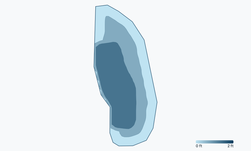
Count 4 structure marks on this chart. The deepest, Deep basin, sits near 3 ft.
Season dates, license requirements, and size and bag limits for Ontario waters are set by the Ontario fishing regulations (FMZ summary) — and special regulations can apply to Bacchus Mud Lake specifically, so confirm the current rules before you fish.
Check the official Ontario fishing regulations →
Bacchus Mud Lake is about 3 ft (1 m) deep at its deepest point. The depth data here comes from the Ontario MNRF survey of 1975, a decades-old survey (a transect sounding survey).
Anglers target yellow perch, northern pike on Bacchus Mud Lake.
Shallow bay flat is the top-rated area: a weed flat in about 1 ft of water that rates prime for yellow perch in spring. The map above holds the full rated-spot list for every species and season.
For yellow perch, the summer bite is best in early morning. Each species page section below lists the seasonal windows, and the map shows a live NOW badge when you're inside one.
Fishing on Bacchus Mud Lake is regulated by the Ontario fishing regulations (FMZ summary). Check the official Ontario regulations for current license requirements, season dates, and size and bag limits — special regulations can apply to this specific water.
Big Rideau Lake 6 mi · Otter Lake 6 mi · Otty Lake 8 mi · Long Lake 10 mi · Bellamys Lake 10 mi · Loon Lake 10 mi · Lake Eloida 14 mi · Mississippi Lake 15 mi · Pike Lake 15 mi · Upper Beverley Lake 16 mi · Little Crosby Lake 18 mi · Lower Beverley Lake 19 mi
See how Bacchus Mud Lake stacks up: best northern pike lakes in Ontario · best yellow perch lakes in Ontario
More water nearby: Leeds and Grenville United Counties fishing maps (54 charts). Browse all Ontario fishing maps. See every water on DepthScout. Depth data: Ontario Ministry of Natural Resources and Forestry, Lake survey data (Open Government Licence – Ontario). How we build these maps. Fish here with a sonar unit that logs? Send us your depth data and we'll improve this chart, credited to you. For fishing guidance only, never navigation.